Contact
- Kapıdağ Yarımadası Ormanlı, 10502 Erdek/Balıkesir
- info@allabouturkiye.com
Between Olive Groves and Open Sea
| MMonday | Open 24 Hours |
| TTuesday | Open 24 Hours |
| WWednesday | Open 24 Hours |
| TThursday | Open 24 Hours |
| FFriday | Open 24 Hours |
| SSaturday | Open 24 Hours |
| SSunday | Open 24 Hours |
Where Ancient Lands Meet the Sea of Marmara
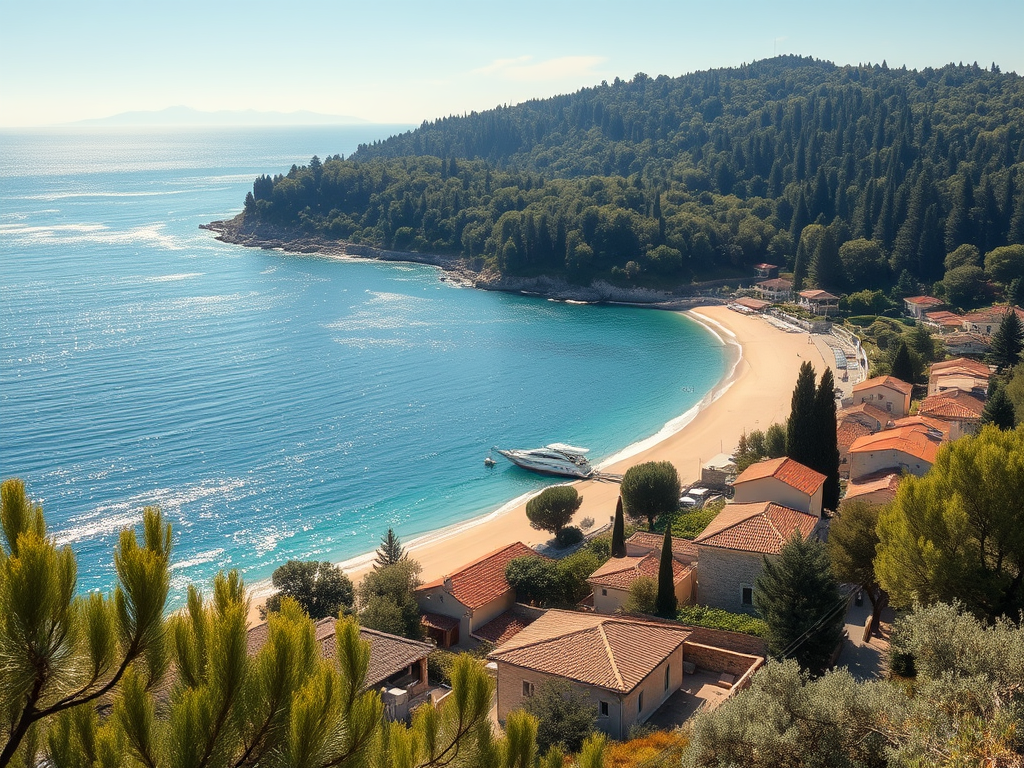
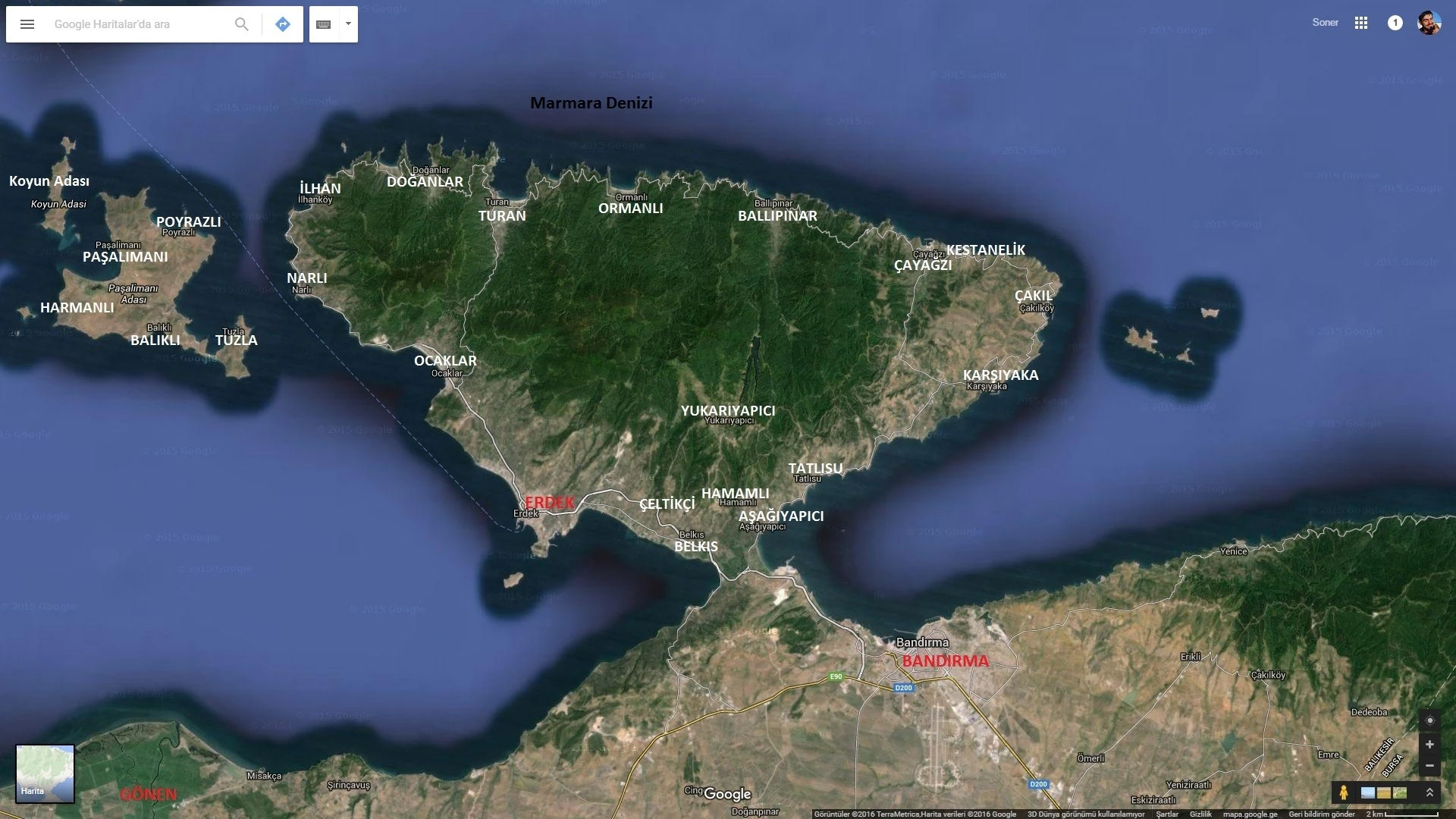
Extending into the Sea of Marmara from northern Balıkesir, the Kapıdağ Peninsula is one of the region’s most distinctive natural landscapes. Defined by rugged coastlines, fertile hills, olive groves, and hidden coves, the peninsula forms a dramatic meeting point between land and sea — a place shaped as much by geology as by centuries of human settlement.
Unlike more uniform coastal regions, Kapıdağ reveals itself slowly. Winding roads connect seaside villages, forested slopes open toward quiet bays, and elevated points offer natural panorama effects over the Marmara Sea. From above, the peninsula appears almost self-contained — a world where agriculture, fishing, and daily life still follow seasonal rhythms.
Historically, the peninsula has been closely linked to the ancient city of Kyzikos, once a major center of trade and culture in antiquity. Its strategic position made Kapıdağ a natural bridge between Anatolia and the wider Mediterranean world. Over time, layers of Greek, Roman, Byzantine, and Ottoman presence left subtle marks across the landscape — visible not in grand monuments alone, but in settlement patterns, cultivated land, and village life.
Today, Kapıdağ Peninsula is valued for its natural diversity rather than large-scale tourism. Olive trees dominate the terrain, coastal waters remain relatively calm, and many villages retain a quiet authenticity. Walking trails, small harbors, and shaded picnic spots invite visitors to slow down and observe rather than rush through.
There is a particular stillness here. Standing above a bay, with Erdek’s coastline in the distance and the Marmara stretching endlessly ahead, you sense how the peninsula has always offered refuge — not isolation, but balance.
Geography & Natural Formation
What makes the Kapıdağ Peninsula especially distinctive is its geological formation. The peninsula is a classic example of a tombolo — a landform created when wave action gradually connects an island to the mainland through the accumulation of sand and gravel.
Once an island, Kapıdağ became a peninsula as coastal currents deposited sediments, forming a narrow isthmus that now links it to the mainland. This land bridge, approximately 1.5 km long, still includes the Belkıs wetland, parts of which have not fully solidified and remain ecologically sensitive.
The peninsula covers an area of roughly 300 square kilometers and features mountainous terrain, with elevations reaching 808 meters at Dedebayırı Hill. Forests dominate large portions of the landscape, while olive groves and coastal vegetation shape lower elevations. Situated between the Bandırma Gulf and the Erdek Gulf, Kapıdağ experiences a Marmara Transitional Climate, characterized by mild winters and moderate rainfall.
Biodiversity & Ecosystem
Kapıdağ Peninsula hosts a remarkably rich ecosystem. Studies have identified over 30 mammal species, including rare sightings of wildcats and lynx, alongside a wide variety of plant life. Forests of pine, oak, beech, hornbeam, chestnut, and olive trees support this biodiversity, making the peninsula an important natural corridor within the Marmara region.
Human Intervention & Environmental Sensitivity
In the mid-20th century, an attempt was made to cut a navigation canal through the isthmus to allow ship passage. However, due to rapid sediment accumulation, the project was abandoned. Traces of this intervention remain visible today, serving as a reminder of the peninsula’s dynamic natural processes and ecological vulnerability.
How to Get There
Kapıdağ Peninsula is easily accessible via Erdek, which serves as its main gateway.
By Car:
Drive to Erdek from Balıkesir or Bandırma, then continue along coastal and interior roads across the peninsula.By Ferry:
Ferries from İstanbul to Erdek operate seasonally, providing direct access.Local Transport:
Minibuses connect Erdek with villages such as Ocaklar and Narlı.
What’s Around
The peninsula connects several important destinations, making it ideal for internal linking:
Erdek – main town and ferry hub
Ocaklar – quiet seaside village
Narlı – traditional coastal settlement
Kyzikos Ancient City – archaeological remains
Bandırma – port city with museums and transport links
Manyas Kuş Cenneti National Park – wetland and bird sanctuary
Best Time to Visit
Spring: Green landscapes, mild temperatures
Summer: Sea access, village life, coastal walks
Autumn: Olive harvest season and warm light
Winter: Quiet, reflective atmosphere
Browse The Map
Reviews And Comments
Suggested Listings
Ayvalık, Balıkesir Turkiye

Aşıklı Höyük | Aksaray
Erdek District, Balıkesir

Not rated yet.
Why don't you register your impressions?